
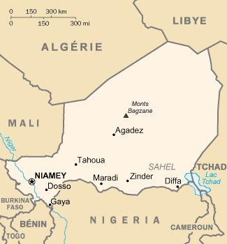
Fichier:Niger carte.gif
Pas de plus haute résolution disponible.
Niger_carte.gif (325 × 350 pixels, taille du fichier : 11 kio, type MIME : image/gif)
Likwé ya mokusé:
| Bolimboli | French map of Niger |
| Mokɔlɔ | of this version : February 2006 |
| Source |
CIA World Factbook / French Wikipedia |
| Mokeli | of the translation : Eric Gaba (Sting) |
| Autorisation (Réutilisation de ce fichier) |
PD |
| Autres versions | original English version : Image:Ng-map.png |
Français : * Sujet : Carte en français du Niger ;
- Source : CIA World Factbook / Wikipédia francophone ;
- Autre version disponible : anglophone : Image:Ng-map.png
- Auteur de la traduction : Eric Gaba (fr:Sting) ;
- Date : Février 2006.
File History of the French Wikipedia :
(suppr) (actu) 3 février 2006 à 17:16 . . Sting (Discuter) . . 330x355 (12 629 octets) (Compléments; correction lac Tchad)
(suppr) (rétab) 3 février 2006 à 16:43 . . Sting (Discuter) . . 330x355 (10 527 octets) (Traductions)
(suppr) (rétab) 17 septembre 2003 à 20:12 . . Looxix (Discuter) . . 330x355 (9 576 octets)
Conditions d’utilisation
Cette image est dans le domaine public parce que son contenu provient du World Factbook, édité par la Central Intelligence Agency des États-Unis d’Amérique.
|
 |
| This work was previously under Public Domain, or a Free License. It has been digitally enhanced and/or modified. This derivative work has been (or is hereby) released into the public domain by its author, Sting at the French Wikipedia project. This applies worldwide. In some countries this is not legally possible; if so:
|
Mokóló mwa kásá
Cliquer sur une date et heure pour voir le fichier tel qu'il était à ce moment-là.
| Mokɔlɔ mpé ntángo | Miniátilɛ | Dimasió | Mosáleli | Ntembe | |
|---|---|---|---|---|---|
| ya sikáwa | 5 dɛsɛ́mbɛ 2013 à 03:36 | | 325 × 350 (11 kio) | Ras67 | cropped |
| 16 yúni 2006 à 23:46 |  | 330 × 355 (12 kio) | Sting | {{Information |Description=French map of Niger |Source=[http://www.cia.gov/cia/publications/factbook/ CIA World Factbook]<br/>/ French Wikipedia |Date=of this version : February 2006 |Author=of the translation : Eric Gaba (Sting) |Permissio |
Bikangisele bya kásá
La page suivante utilise ce fichier :
Usage global du fichier
Les autres wikis suivants utilisent ce fichier :
- Utilisation sur ar.wikipedia.org
- Utilisation sur ceb.wikipedia.org
- Utilisation sur es.wikipedia.org
- Utilisation sur fi.wikipedia.org
- Utilisation sur frp.wikipedia.org
- Utilisation sur fr.wikipedia.org
- Utilisation sur fr.wikinews.org
- Utilisation sur ht.wikipedia.org
- Utilisation sur id.wikipedia.org
- Utilisation sur it.wikipedia.org
- Utilisation sur jv.wikipedia.org
- Utilisation sur la.wikipedia.org
- Utilisation sur lij.wikipedia.org
- Utilisation sur lv.wikipedia.org
- Utilisation sur mg.wikipedia.org
- Utilisation sur pcd.wikipedia.org
- Utilisation sur pt.wikipedia.org
- Utilisation sur ro.wikipedia.org
- Utilisation sur scn.wikipedia.org
- Utilisation sur se.wikipedia.org
- Utilisation sur so.wikipedia.org
- Utilisation sur vec.wikipedia.org