
Fichier:LanguageMap-Kikongo-Kituba.png

Taille de cet aperçu : 800 × 529 pixels. Autres résolutions : 320 × 212 pixels | 640 × 423 pixels | 1 024 × 677 pixels | 1 420 × 939 pixels.
Fichier d’origine (1 420 × 939 pixels, taille du fichier : 89 kio, type MIME : image/png)
Likwé ya mokusé:
| Bolimboli |
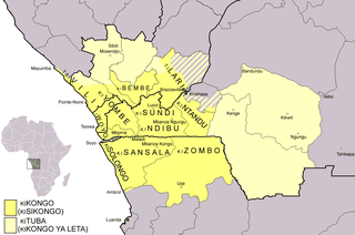
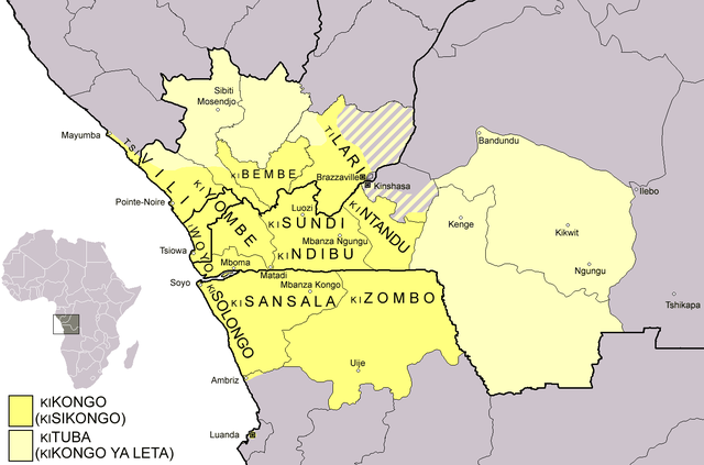
Dialect map of Kikongo. Dark yellow areas are inhabited mainly by first language speakers of the various dialects/languages of Kikongo. Names of some dialects/languages are written on the map. Pale yellow areas are inhabited by first and second language speakers of Kituba (a.k.a. Kikongo ya Leta), which is the lingua franca in the area. Kituba is understood by most speakers of Kikongo. Map drawn by Risto Kupsala. Details are based on the language maps of Ethnologue and several other sources. |
| Mokɔlɔ | 2 sánzá ya mínei 2006 (date de téléversement originale) |
| Source | No machine-readable source provided. Own work assumed (based on copyright claims). |
| Mokeli | No machine-readable author provided. Rasulo~commonswiki assumed (based on copyright claims). |
Conditions d’utilisation
| Moi, propriétaire des droits d’auteur sur cette œuvre, la place dans le domaine public. Ceci s'applique dans le monde entier. Dans certains pays, ceci peut ne pas être possible ; dans ce cas : J’accorde à toute personne le droit d’utiliser cette œuvre dans n’importe quel but, sans aucune condition, sauf celles requises par la loi. |
Mokóló mwa kásá
Cliquer sur une date et heure pour voir le fichier tel qu'il était à ce moment-là.
| Mokɔlɔ mpé ntángo | Miniátilɛ | Dimasió | Mosáleli | Ntembe | |
|---|---|---|---|---|---|
| ya sikáwa | 25 febwáli 2021 à 00:37 | | 1 420 × 939 (89 kio) | Somebody040404 | Reverted to version as of 10:10, 29 March 2018 (UTC) |
| 25 febwáli 2021 à 00:26 |  | 1 420 × 939 (82 kio) | Somebody040404 | ||
| 29 mársi 2018 à 10:10 |  | 1 420 × 939 (89 kio) | Maphobbyist | South Sudan border | |
| 20 dɛsɛ́mbɛ 2007 à 21:24 |  | 1 420 × 939 (60 kio) | Rasulo~commonswiki | Dialect map of Kikongo. Dark yellow areas are inhabited mainly by native speakers of the various dialects/languages of Ki(si)kongo. Names of some dialects/languages are written on the map. Pale yellow areas are inhabited by first and second language speak | |
| 22 yúli 2006 à 12:12 |  | 718 × 518 (26 kio) | Rasulo~commonswiki | ||
| 2 apríli 2006 à 09:49 |  | 571 × 471 (20 kio) | Rasulo~commonswiki | Dialect map of Kikongo Dark green areas are inhabited mainly by first language speakers of the various dialects/languages of Kikongo. Names of some dialects/languages are written on the map. Light green areas are inhabited by first and second language spe |
Bikangisele bya kásá
La page suivante utilise ce fichier :
Usage global du fichier
Les autres wikis suivants utilisent ce fichier :
- Utilisation sur af.wikipedia.org
- Utilisation sur ar.wikipedia.org
- Utilisation sur ast.wikipedia.org
- Utilisation sur az.wiktionary.org
- Utilisation sur bn.wikipedia.org
- Utilisation sur ca.wikipedia.org
- Utilisation sur cs.wikipedia.org
- Utilisation sur da.wikipedia.org
- Utilisation sur de.wikipedia.org
- Utilisation sur en.wikipedia.org
- Utilisation sur eo.wikipedia.org
- Utilisation sur es.wikipedia.org
- Utilisation sur eu.wikipedia.org
- Utilisation sur fi.wikipedia.org
- Utilisation sur frr.wikipedia.org
- Utilisation sur fr.wikipedia.org
Voir davantage sur l’utilisation globale de ce fichier.