
Fichier:Mars rocks.jpg
Fichier d’origine (2 800 × 2 836 pixels, taille du fichier : 3,08 Mio, type MIME : image/jpeg)
Likwé ya mokusé:
| Bolimboli |
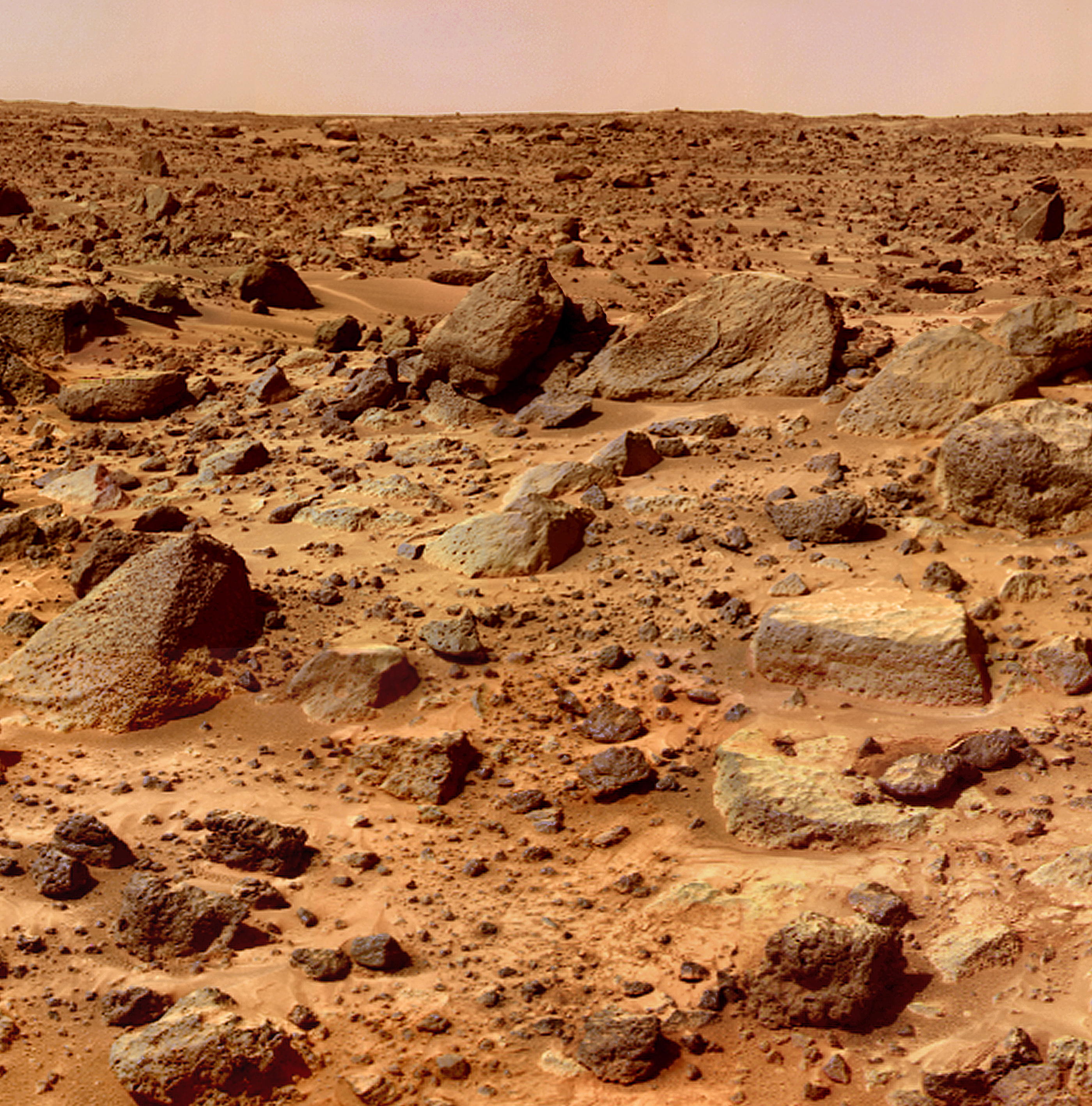
English: The Twin Peaks are modest-size hills to the southwest of the Mars Pathfinder landing site. They were discovered on the first panoramas taken by the IMP camera on the 4th of July, 1997, and subsequently identified in Viking Orbiter images taken over 20 years ago. The peaks are approximately 30-35 meters (-100 feet) tall. North Twin is approximately 860 meters (2800 feet) from the lander, and South Twin is about a kilometer away (3300 feet). The scene includes bouldery ridges and swales or "hummocks" of flood debris that range from a few tens of meters away from the lander to the distance of the South Twin Peak.
The composite color frames that make up this "right-eye" image consist of 7 frames, taken with different color filters that were enlarged by 500% and then co-added using Adobe Photoshop to produce, in effect, a super-resolution panchromatic frame that is sharper than an individual frame would be. This panchromatic frame was then colorized with the red, green, and blue filtered images from the same sequence. The color balance was adjusted to approximate the true color of Mars. This image and PIA02405(left eye) make up a stereo pair. Mars Pathfinder is the second in NASA's Discovery program of low-cost spacecraft with highly focused science goals. The Jet Propulsion Laboratory, Pasadena, CA, developed and manages the Mars Pathfinder mission for NASA's Office of Space Science, Washington, D.C. JPL is a division of the California Institute of Technology (Caltech). The IMP was developed by the University of Arizona Lunar and Planetary Laboratory under contract to JPL. Peter Smith is the Principal Investigator. |
| Mokɔlɔ | entre le 4 sánzá ya nsambo 1997 et le 27 sánzá ya libwá 1997 |
| Source | http://photojournal.jpl.nasa.gov/catalog/PIA02406 |
| Mokeli | NASA/JPL |
Cette image ou vidéo a été cataloguée par le Jet Propulsion Lab de la National Aeronautics and Space Administration (NASA) des États-Unis sous Photo ID : PIA02406.Ce bandeau n’indique rien sur le statut de l’œuvre au regard du droit d'auteur. Un bandeau de droit d’auteur est requis. Voir Commons:À propos des licences pour plus d’informations. Autres langues :
|
Conditions d’utilisation
| Ce fichier provient de la NASA. Sauf exception, les documents créés par la NASA ne sont pas soumis à copyright. Pour plus d'informations, voir la politique de copyright de la NASA. | ||
 |
Attention :
|
Mokóló mwa kásá
Cliquer sur une date et heure pour voir le fichier tel qu'il était à ce moment-là.
| Mokɔlɔ mpé ntángo | Miniátilɛ | Dimasió | Mosáleli | Ntembe | |
|---|---|---|---|---|---|
| ya sikáwa | 27 novɛ́mbɛ 2011 à 17:15 | | 2 800 × 2 836 (3,08 Mio) | Ras67 | high resolution |
| 7 mársi 2007 à 18:52 |  | 338 × 343 (36 kio) | Sbandrews | {{Information |Description=Mars rocks |Source=http://photojournal.jpl.nasa.gov/catalog/PIA02406 |Date=2007-03-07 |Author=NASA |Permission=NASA public domain |other_versions= }} |
Bikangisele bya kásá
La page suivante utilise ce fichier :
Usage global du fichier
Les autres wikis suivants utilisent ce fichier :
- Utilisation sur af.wikipedia.org
- Utilisation sur ar.wikipedia.org
- Utilisation sur as.wikipedia.org
- Utilisation sur bn.wikipedia.org
- Utilisation sur ckb.wikipedia.org
- Utilisation sur de.wikipedia.org
- Utilisation sur de.wiktionary.org
- Utilisation sur en.wikipedia.org
- Utilisation sur fa.wikipedia.org
- Utilisation sur fr.wikipedia.org
- Utilisation sur glk.wikipedia.org
- Utilisation sur he.wikipedia.org
- Utilisation sur hif.wikipedia.org
- Utilisation sur ht.wikipedia.org
- Utilisation sur incubator.wikimedia.org
- Utilisation sur ku.wikipedia.org
- Utilisation sur la.wikipedia.org
- Utilisation sur ml.wikipedia.org
- Utilisation sur my.wikipedia.org
- Utilisation sur mzn.wikipedia.org
- Utilisation sur no.wikibooks.org
- Utilisation sur pl.wikipedia.org
- Utilisation sur si.wikipedia.org
- Utilisation sur ta.wikipedia.org
- Utilisation sur tr.wikipedia.org
- Utilisation sur ug.wikipedia.org
- Utilisation sur uk.wikipedia.org
- Utilisation sur vi.wikipedia.org
Voir davantage sur l’utilisation globale de ce fichier.