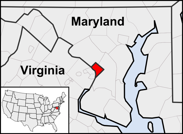
Fichier:Washington, D.C. locator map.svg

Taille de cet aperçu PNG pour ce fichier SVG : 750 × 550 pixels. Autres résolutions : 320 × 235 pixels | 640 × 469 pixels | 1 024 × 751 pixels | 1 280 × 939 pixels | 2 560 × 1 877 pixels.
Fichier d’origine (Fichier SVG, nominalement de 750 × 550 pixels, taille : 160 kio)
Mokóló mwa kásá
Cliquer sur une date et heure pour voir le fichier tel qu'il était à ce moment-là.
| Mokɔlɔ mpé ntángo | Miniátilɛ | Dimasió | Mosáleli | Ntembe | |
|---|---|---|---|---|---|
| ya sikáwa | 23 yúli 2011 à 03:23 |  | 750 × 550 (160 kio) | Patrickneil | Reverted to version as of 03:04, 23 July 2011 |
| 23 yúli 2011 à 03:21 |  | 750 × 550 (161 kio) | Patrickneil | Reverted to version as of 03:14, 23 July 2011 | |
| 23 yúli 2011 à 03:20 |  | 750 × 550 (161 kio) | Patrickneil | frame | |
| 23 yúli 2011 à 03:14 |  | 750 × 550 (161 kio) | Patrickneil | thicker frame | |
| 23 yúli 2011 à 03:04 |  | 750 × 550 (160 kio) | Patrickneil | straightening Maryland and Delaware borders | |
| 15 augústo 2010 à 02:09 |  | 750 × 550 (202 kio) | Patrickneil | Delaware River again | |
| 15 augústo 2010 à 01:51 |  | 750 × 550 (274 kio) | Patrickneil | Delaware River border | |
| 15 augústo 2010 à 01:42 |  | 750 × 550 (273 kio) | Patrickneil | forgot border on Smith Island | |
| 15 augústo 2010 à 01:34 |  | 750 × 550 (273 kio) | Patrickneil | county borders below state | |
| 15 augústo 2010 à 01:32 |  | 750 × 550 (274 kio) | Patrickneil | changes by request |
Bikangisele bya kásá
La page suivante utilise ce fichier :
Usage global du fichier
Les autres wikis suivants utilisent ce fichier :
- Utilisation sur af.wikipedia.org
- Utilisation sur an.wikipedia.org
- Utilisation sur ar.wikipedia.org
- Utilisation sur arz.wikipedia.org
- Utilisation sur as.wikipedia.org
- Utilisation sur azb.wikipedia.org
- Utilisation sur bh.wikipedia.org
- Utilisation sur bs.wikipedia.org
- Utilisation sur ceb.wikipedia.org
- Utilisation sur ckb.wikipedia.org
- Utilisation sur en.wikipedia.org
- Utilisation sur en.wikinews.org
- Utilisation sur es.wikipedia.org
- Utilisation sur es.wiktionary.org
- Utilisation sur et.wikipedia.org
- Utilisation sur fr.wikipedia.org
- Utilisation sur fr.wiktionary.org
- Utilisation sur fy.wikipedia.org
- Utilisation sur gv.wikipedia.org
- Utilisation sur hu.wikipedia.org
- Utilisation sur ia.wikipedia.org
- Utilisation sur id.wikipedia.org
- Utilisation sur ilo.wikipedia.org
- Umuna a Panid
- Washington, D.C.
- Wikipedia:Ammom kadi/2013
- Plantilia:Ammom kadi/Agosto 3
- Plantilia:Ammom kadi/Septiembre 22
- Plantilia:Ammom kadi/Nobiembre 11
- Plantilia:Ammom kadi/Disiembre 31
- Plantilia:Ammom kadi/Enero 16
- Plantilia:Ammom kadi/Marso 6
- Plantilia:Ammom kadi/Abril 25
- Plantilia:Ammom kadi/Hunio 14
- Wikipedia:Umuna a Panid/Intono bigat
- Utilisation sur incubator.wikimedia.org
- Utilisation sur it.wikipedia.org
- Utilisation sur jam.wikipedia.org
- Utilisation sur ja.wikipedia.org
- Utilisation sur jbo.wikipedia.org
- Utilisation sur ko.wikipedia.org
- Utilisation sur lb.wikipedia.org
- Utilisation sur lfn.wikipedia.org
Voir davantage sur l’utilisation globale de ce fichier.
