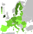
Fichier:Knowledge of English EU map.svg

Le contenu de la page n’est pas pris en charge dans d’autres langues.
Útá Wikipedia.

Fichier d’origine(Fichier SVG, nominalement de 590 × 603 pixels, taille : 671 kio)

Ce fichier provient de Wikimedia Commons et peut être utilisé par d'autres projets. Sa description sur sa page de description est affichée ci-dessous.

Cette image (ou toutes les images dans cet article ou cette catégorie) est un graphique créée par un logiciel, dont les données ou formules n'ont pas été indiquées. Afin de permettre à d'autres éditeurs d'améliorer ou de refaire cette image, et de satisfaire les besoins de la licence libre, les informations suivantes devraient être fournies :
  • Logiciel(s) utilisés
  • Données utilisées
  • Séquence d'instructions utilisées pour créer le graphique
  • Rapide description d'éventuelles étapes de post-production.
Enlevez ce bandeau une fois que toutes ces informations ont été incluses sur cette page.

Deutsch  English  français  magyar  Nederlands  Plattdüütsch  suomi  македонски  русский  日本語  中文  中文(简体)‎  +/−

Likwé ya mokusé:

Bolimboli
English: Map, in English of the knowledge of English language in EU.
Deutsch: Karte, die auf Englisch Kenntnisse der englischen Sprache in der EU zeigt.
Français : Carte des connaissances de l'anglais, en anglais, dans l'Union européenne.
Mokɔlɔ (UTC)
Source
Mokeli
Autres versions


Cette image a été retouchée, ce qui signifie qu'elle a été modifiée par ordinateur et est différente de l'image d'origine. Liste des modifications : Hybridised to make vector version of English map. L'image d'origine se trouve ici : Knowledge English EU map.png. Modifications effectuées par Alphathon.

w:fr:Creative Commons
paternité partage à l’identique
Ce fichier est disponible selon les termes de la licence Creative Commons Attribution – Partage dans les Mêmes Conditions 3.0 (non transposée).
Vous êtes libre :
  • de partager – de copier, distribuer et transmettre cette œuvre
  • d’adapter – de modifier cette œuvre
Sous les conditions suivantes :
  • paternité – Vous devez donner les informations appropriées concernant l'auteur, fournir un lien vers la licence et indiquer si des modifications ont été faites. Vous pouvez faire cela par tout moyen raisonnable, mais en aucune façon suggérant que l’auteur vous soutient ou approuve l’utilisation que vous en faites.
  • partage à l’identique – Si vous modifiez, transformez, ou vous basez sur cette œuvre, vous devez distribuer votre contribution sous la même licence ou une licence compatible avec celle de l’original.

Journal des téléversements d’origine

This image is a derivative work of the following images:

  • File:Knowledge_of_German_EU_map.png licensed with PD-self
    • 2009-05-23T22:36:14Z HernauMan 1218x1245 (56214 Bytes) {{Information |Description={{en|1=Knowledge of German language in EU with Croatia, Bosnia and Herzegovina, Switzerland and Turkey. }} |Source=Own work by uploader |Author=[[User:HernauMan|HernauMan]] |Date=2009-05-15 |Permiss
  • File:Knowledge_English_EU_map.png licensed with PD-self
    • 2010-08-13T09:57:14Z RoseAphro 1218x1245 (78412 Bytes) Reverted to version as of 11:13, 2 January 2009 See Discussion
    • 2009-11-10T09:34:49Z Scooter20 1218x1245 (85789 Bytes) Reverted to version as of 10:56, 13 March 2009
    • 2009-07-07T03:55:09Z Kombie2 1218x1245 (61153 Bytes) Corrected wrong text colour in the "NA" in the legend; in an informational map, text colours should be consistent to maximize readability. Also, customarily, a forward slash is entered between the letter 'N' and the letter
    • 2009-03-13T10:56:15Z MacedonianBoy 1218x1245 (85789 Bytes) Since Croatia and Turkey are not part of the EU and they shown, and Macedonia should be since it is candidate
    • 2009-01-02T11:13:54Z The Duke of Waltham 1218x1245 (78412 Bytes) Reverted to version as of 23:47, 15 February 2008 (FYROM is not in the EU)
    • 2008-12-11T12:35:26Z MacedonianBoy 1218x1245 (85789 Bytes)
    • 2008-02-15T23:47:46Z RedCoat 1218x1245 (78412 Bytes) Add Gibraltar.
    • 2006-12-19T09:56:40Z Hoshie 1218x1245 (85776 Bytes) Added Montenegro. Under same license as orginal
    • 2006-11-12T13:50:19Z Aaker 1218x1245 (85716 Bytes) Knowledge of English in the European Union, according to: "Special Eurobarometer 243" of the European Commission with the title "Europeans and their Languages" Made by myself

Téléversé avec derivativeFX

Légendes

Ajoutez en une ligne la description de ce que représente ce fichier

Éléments décrits dans ce fichier

dépeint lifalansɛ́

27 sánzá ya mwambe 2010

type MIME lifalansɛ́

image/svg+xml

Mokóló mwa kásá

Cliquer sur une date et heure pour voir le fichier tel qu'il était à ce moment-là.

Mokɔlɔ mpé ntángoMiniátilɛDimasióMosáleliNtembe
ya sikáwa3 febwáli 2020 à 10:36Miniátilɛ ya versió ya 3 febwáli 2020 à 10:36590 × 603 (671 kio)DarrancUpdate since UK left the EU
15 febwáli 2015 à 23:30Miniátilɛ ya versió ya 15 febwáli 2015 à 23:30590 × 603 (671 kio)LeftcryUpdate layout and information
17 ɔkɔtɔ́bɛ 2011 à 11:49Miniátilɛ ya versió ya 17 ɔkɔtɔ́bɛ 2011 à 11:491 212 × 1 242 (552 kio)Treehilldeletion of Turkey, I let only candidate country with an accession date planned (Croatia and Iceland).
7 sɛtɛ́mbɛ 2011 à 06:34Miniátilɛ ya versió ya 7 sɛtɛ́mbɛ 2011 à 06:341 212 × 1 242 (552 kio)Treehill(norway was not deleted before, maybe an error)
6 sɛtɛ́mbɛ 2011 à 20:58Miniátilɛ ya versió ya 6 sɛtɛ́mbɛ 2011 à 20:581 212 × 1 242 (552 kio)Treehilldeletion of Norway, as explained previously. Not an EU country (note that the name of the file is "Knowledge_of_English_EU_map.svg").
6 sɛtɛ́mbɛ 2011 à 19:50Miniátilɛ ya versió ya 6 sɛtɛ́mbɛ 2011 à 19:501 212 × 1 242 (552 kio)TreehillI deleted Switzerland which is neither in the EU nor a candidate country.
12 yúli 2011 à 11:12Miniátilɛ ya versió ya 12 yúli 2011 à 11:121 212 × 1 242 (552 kio)J intelaAdded Norway and Switzerland http://en.wikipedia.org/wiki/List_of_countries_by_English-speaking_population
8 apríli 2011 à 19:08Miniátilɛ ya versió ya 8 apríli 2011 à 19:081 212 × 1 242 (552 kio)AlphathonImproved British Isles
27 augústo 2010 à 17:42Miniátilɛ ya versió ya 27 augústo 2010 à 17:421 212 × 1 242 (520 kio)Alphathon{{Information |Description={{en|1=Knowledge of English language in EU}} |Source=*File:Knowledge_of_German_EU_map.png *File:Knowledge_English_EU_map.png |Date=2010-08-27 17:41 (UTC) |Author=*File:Knowledge_of_German_EU_map.png: [[User:Her

Aucune page n’utilise ce fichier.

Usage global du fichier

Les autres wikis suivants utilisent ce fichier :

Voir davantage sur l’utilisation globale de ce fichier.

Métadonnées