Aller au contenu

Fichier:Moon Farside LRO.jpg

Le contenu de la page n’est pas pris en charge dans d’autres langues.
Útá Wikipedia.

Fichier d’origine (18 000 × 18 000 pixels, taille du fichier : 85,34 Mio, type MIME : image/jpeg)

Ce fichier provient de Wikimedia Commons et peut être utilisé par d'autres projets. Sa description sur sa page de description est affichée ci-dessous.

Avertissement Certains navigateurs peuvent avoir des difficultés à afficher cette image à sa résolution complète : elle possède un nombre de pixels singulièrement élevé et peut ne pas se charger correctement ou faire planter votre navigateur. Open large-image-viewer

Lower-resolution versions: 6000px, 3000px, and 1000px

Likwé ya mokusé:

Bolimboli
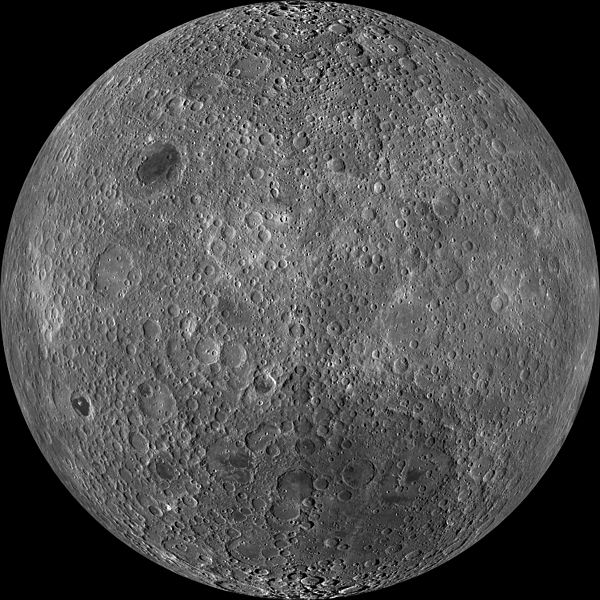
English: Far side of the moon, by NASA's Lunar Reconnaissance Orbiter. Orthographic projection centred at 180° longitude, 0° latitude.

Because the moon is tidally locked (meaning the same side always faces Earth), it was not until 1959 that the farside was first imaged by the Soviet Luna 3 spacecraft (hence the Russian names for prominent farside features, such as Mare Moscoviense). And what a surprise – unlike the widespread maria on the nearside, basaltic volcanism was restricted to a relatively few, smaller regions on the farside, and the battered highlands crust dominated. A different world from what we saw from Earth.

Of course, the cause of the farside/nearside asymmetry is an interesting scientific question. Past studies have shown that the crust on the farside is thicker, likely making it more difficult for magmas to erupt on the surface, limiting the amount of farside mare basalts. Why is the farside crust thicker? That is still up for debate, and in fact several presentations at this week's Lunar and Planetary Science Conference attempt to answer this question.

The Clementine mission obtained beautiful mosaics with the sun high in the sky (low phase angles), but did not have the opportunity to observe the farside at sun angles favorable for seeing surface topography. This WAC mosaic provides the most complete look at the morphology of the farside to date and will provide a valuable resource for the scientific community. And it's simply a spectacular sight!

The Lunar Reconnaissance Orbiter Camera (LROC) Wide Angle Camera (WAC) is a push-frame camera that captures seven color bands (321, 360, 415, 566, 604, 643, and 689 nm) with a 57 km swath (105 km swath in monochrome mode) from a 50 km orbit. One of the primary objectives of LROC is to provide a global 100 m/px monochrome (643 nm) base map with incidence angles between 55° and 70° at the equator, lighting that is favorable for morphological interpretations. Each month, the WAC provides nearly complete coverage of the Moon under unique lighting. As an added bonus, the orbit-to-orbit image overlap provides stereo coverage. Reducing all these stereo images into a global topographic map is a big job, which is being led by LROC Team Members from the German Aerospace Center (Deutsches Zentrum für Luft- und Raumfahrt; DLR). Several preliminary WAC topographic products have appeared in LROC featured images over the past year (Orientale basin, Sinus Iridum). The WAC topographic dataset will be completed and released later this year.

The global mosaic released today is comprised of over 15,000 WAC images acquired between November 2009 and February 2011. The non-polar images were map-projected onto the GLD100 shape model (WAC derived 100 m/px DTM), while polar images were map-projected on the LOLA shape model. In addition, the LOLA-derived crossover-corrected ephemeris and an improved camera pointing provide accurate positioning (better than 100 m) of each WAC image.
Mokɔlɔ entre sánzá ya zómi na mɔ̌kɔ́ 2009 et sánzá ya míbalé 2011
date QS:P,+2050-00-00T00:00:00Z/7,P1319,+2009-11-00T00:00:00Z/10,P1326,+2011-02-00T00:00:00Z/10
Source http://wms.lroc.asu.edu/lroc_browse/view/WAC_GL180 (see also http://photojournal.jpl.nasa.gov/catalog/PIA14021)
Mokeli NASA/GSFC/Arizona State University
Autres versions Lower-resolution versions: 6000px, 3000px, and 1000px
Cette image ou vidéo a été cataloguée par le
Jet Propulsion Lab
de la
National Aeronautics and Space Administration
(NASA) des États-Unis sous Photo ID : PIA14021.

Ce bandeau n’indique rien sur le statut de l’œuvre au regard du droit d'auteur. Un bandeau de droit d’auteur est requis. Voir Commons:À propos des licences pour plus d’informations.
Autres langues :

Lisásɛ

Public domain Ce fichier provient de la NASA. Sauf exception, les documents créés par la NASA ne sont pas soumis à copyright. Pour plus d'informations, voir la politique de copyright de la NASA.
Attention :
Annotations
InfoField
This image is annotated: View the annotations at Commons

Légendes

Ajoutez en une ligne la description de ce que représente ce fichier

Éléments décrits dans ce fichier

dépeint lifalansɛ́

Mokóló mwa kásá

Cliquer sur une date et heure pour voir le fichier tel qu'il était à ce moment-là.

Mokɔlɔ mpé ntángoMiniátilɛDimasióMosáleliNtembe
ya sikáwa19 mársi 2014 à 23:47Miniátilɛ ya versió ya 19 mársi 2014 à 23:4718 000 × 18 000 (85,34 Mio)HuntsterHigh resolution mosaic.
9 apríli 2011 à 04:12Miniátilɛ ya versió ya 9 apríli 2011 à 04:121 600 × 1 600 (1,44 Mio)Bubba73{{Information |Description ={{en|1=Far side of the Moon, by NASA's Lunar Recon. Orbiter}} |Source =http://apod.nasa.gov/apod/image/1104/farside_lro1600.jpg |Author =NASA - LRO |Date =2011? |Permission = |other_versions = }

Aucune page n’utilise ce fichier.

Usage global du fichier

Les autres wikis suivants utilisent ce fichier :

Voir davantage sur l’utilisation globale de ce fichier.